Turicleta
Férez
Featured Destination

Férez

Albacete
Cómo llegar

This town is also known as “the mountain jewel.” It is located on the southern course of the Segura River, in a landscape dominated by cultivated fields and soft terrain undulations. Its urban center hides beautiful corners, and in its surroundings we can enjoy outdoor sports such as hunting and fishing.

2 Cycling Routes
1 station available
Where do you want to rent your bike?

Stations inFérez

Find electric bike stations available in the city.

View all

Sobre Férez

<p><strong>Heritage</strong></p>

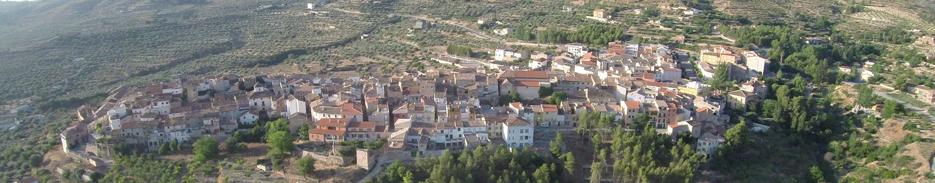
Located in a beautiful environment and near the Taibilla canal, in an area dominated by cultivated fields and gentle terrain undulations, surrounded by splendid nature, lies the town of Férez. Its lands are mountainous, with few plains. The characteristics of the territory correspond to mid-mountain landscape, with crops of extraordinary quality. Férez is bathed by the Segura River, whose passage is facilitated by two bridges: one in the hamlet of Alcantarilla de Jover, now submerged by the reservoir waters, and the other in Híjar. In its valley of olive and almond trees several springs emerge, feeding different streams that converge at the Molino de la Mora.

The foothills of these mountains were dedicated to the exploitation of esparto. This plant has had a long tradition in Férez, being considered almost native to the region. Its urban center maintains the Arab layout, with the distinctive atmosphere left in these lands by the long period of Muslim rule. Its streets are narrow and winding, offering secluded corners where the medieval environment can be felt. From the period in which the Order of Santiago governed the town, several stately façades with Castilian character still remain, scattered through the urban center, revealing its splendid medieval past and guarding its memory from being forgotten. The town itself was designed for its own defense and, as its Roman-era name indicates—FREZ—its meaning is “stronghold” or “fortress.”

The names of the streets depend on their function and meaning:

  • Orden Street: Refers to the town’s belonging to the Order of Santiago.
  • Cantarería Street: Named for the location of several pottery workshops where water jugs were made.
  • De la Torre Street: Named for the tower that once existed at the top of the street and formed part of the fortress of Férez.
  • Santa Ana Street: Named in honor of the hermitage located there.
  • Arrabal Street: In medieval times, this was a neighborhood located outside th

<p><strong>Fauna and Flora</strong></p>

The Lentiscar of Férez is an area of the municipality located in the southeast, with a hamlet that remained inhabited until 4 or 5 decades ago. These farms have a basin—formerly a natural pond—that stores water from several small springs. The nearby hills, once covered with Aleppo pine, holm oak and shrubland, were partially replaced—until the early 20th century—by vast esparto fields, now substituted by almond groves and some vineyards. The areas with the best soil are used for cultivation, and the olive tree stands out intensely: an evergreen reaching 12–15 meters in height and capable of living many years, with a wide base and compact appearance. The oldest trees have hollow trunks. Their leaves are opposite, lanceolate and pointed. Their flowering period is from June to August.

The mountains are mostly covered by shrubs such as rosemary, black juniper, white rockrose, albarda, torvisco, prickly asparagus, mastic, kermes oak, gorse and brooms, lavender and esparto grass. On rocky outcrops, the “friar’s crown” plant is notable. In sheltered environments such as ravines appear species like durillo, strawberry tree, aladiermo, labiérnago and the climbing sarsaparilla.

Watercourses, both temporary and permanent, are accompanied by characteristic vegetation featuring oleander, often growing alongside emborrachacabras, cornicabras, tamarisks and willows. Among the tall herbs, fireweed, purple loosestrife, the legume dorycminum, mint and reeds stand out; the latter traditionally used to manufacture agricultural tools, along with cattails. In cooler zones poplars and hackberries are common.

This vegetation reaches its full development on the banks of the Segura River, where species such as rushes, sedges and cattails grow abundantly. In sandy and gravel sediment banks, specialized vegetation develops, where a “candilera” plant stands out. It stores its food reserves in various caches, preparing for scarcity periods. It builds its nests in treetops with twigs, leaves, bark, grasses, moss, feathers and hair, which it uses as shelter. Its diet is varied, consisting of fruits and berries, tender shoots and buds, stems and seeds, pine nuts, fungi, insects, eggs and chicks of birds. It reproduces in groups of four to eight, with the breeding season occurring early or late in spring.