Las Vegas and Alcarria Madrileña
Discover the natural and cultural heritage of Las Vegas and Alcarria Madrileña by electric bike
About Las Vegas and Alcarria Madrileña
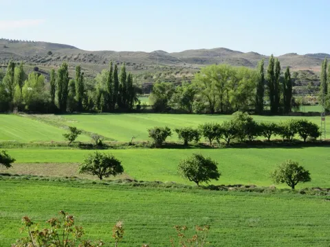
Las Vegas and Alcarria Madrileña form a unique territory in the Community of Madrid, where river plain landscapes, Alcarrian plateaus and charming villages that are committed to sustainable cycling tourism merge.
Discover by electric bike natural landscapes, historical heritage and authentic rural life in Madrid in a region full of surprises for cyclists.
Mapa de la Comarca
9 destinosFeatured routes
Discover the paths that connect these unique destinations.

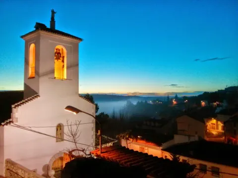
Route 2 Railways with history - Tielmes
TielmesThe ancient railways built in Las Vegas madrileñas between the 19th and 20th centuries to connect the region with the capital, simultaneously allowing the export of industrial and agricultural products, are now converted into pleasant and comfortable bike lanes and greenways perfect for cycling routes of different levels and content. An interesting route starts from the municipality of Tielmes, of Roman origin with interesting medieval heritage, and runs along a stretch of the Greenway of Tajuña to Carabaña. It then continues along the first section adapted from the Train of the 40 Days, to the village of Valdaracete. The route departs from the stone bridge of Tajuña and at the intersection of the hermitage of San Isidro begins a rural path that ascends to the viewpoint of the bench “Tielmes is heart,” with an extraordinary panoramic view of the urban ensemble on the hillside of the valley. The Greenway passes through the welcoming site of the hermitage of the Santos Niños and at the municipal boundary is the entrance to the Azud de Vaciabotas, known as the “waterfall” of Tajuña.
The streets of Carabaña are outside the route, on the other side of the Tajuña River, it is one of the oldest populations in the Community of Madrid and to enter you must cross the Tajuña bridge, of Roman origin and reconstructed in the 18th century. The cycling itinerary crosses the road of Estremera and connects with the layout of the Train of the 40 Days, which is also adapted as a Greenway between Carabaña and Estremera. The Train of the 40 Days or Vía Negrín was built in a hurry during the Civil War to supply the Republican troops fighting in Madrid.

Greenway Route Tielmes - Ambite
TielmesThe ancient railways built in Las Vegas de Madrid between the 19th and 20th centuries to connect the region with the capital, simultaneously allowing the exit of industrial and agricultural products, are now converted into bicycle paths and greenways perfect for bicycle routes of different levels and content.
An interesting route starts from the municipality of Tielmes, of Roman origin and with interesting medieval heritage, and runs along a stretch of the Tajuña Greenway to Carabaña. It then continues along the first conditioned part of the 40 Days Train to the village of Valdaracete.
The route departs from the stone bridge of Tajuña and at the junction of the hermitage of San Isidro begins a rural path that ascends to the viewpoint of the bench “Tielmes is heart”, with an extraordinary panoramic view of the urban ensemble on the hillside of the valley. The Greenway passes through the cozy spot of the hermitage of the Holy Children and at the municipal boundary is the Vaciabotas Weir, known as the “waterfall” of Tajuña.
The streets of Carabaña are outside the route, on the other side of the river Tajuña. It is one of the oldest populations in the Community of Madrid and to enter, one must cross the Tajuña bridge, of Roman origin and reconstructed in the 18th century.
Upon leaving Carabaña towards the junction of the road that connects the municipality with Estremera, there is a junction shaped like a “Y” that leads to the next municipality: Orusco. In the stretch between Carabaña and Orusco, the route runs between excavated rock walls for the railway, occasionally passing under stone bridges. This is one of the most photogenic and unique stretches. Finally, the Greenway enters Orusco heading south, continuing after passing the village in a southwest direction towards Ambite.
Warning: shared space with motor vehicles.
Types of path
- Bicycle lane: 36.20 km
- Path: 1.34 km
- Road: 1.02 km
- Street: 0.214 km

Route 3 Balcón del Tajuña - Valdelaguna
ValdelagunaImportant to indicate: Warning: shared space with motor vehicles.
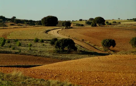
The “Balcón del Tajuña” is a scenic route through the high plateaus of Mediterranean forest, olive groves, and crops of the municipalities of Valdelaguna and Perales de Tajuña, connecting several sections of the local hiking trail Ruta de las Fuentes to reach the edge of the slopes of holm oaks, junipers, kermes oaks, thymes, lavenders, and other aromatic plants that cover the slopes that fall towards the great alluvial plain of the Tajuña valley.
The area offers extraordinary views of the splendid vega of the Madrid river and the towns of Perales de Tajuña and Morata de Tajuña. The natural balcony is on a narrow and somewhat stony path, ideal for cyclotourists who enjoy technical and simple trails. The path is flat and the cycling level is one hundred percent, a fun one-kilometer stretch to link the mountain of La Mesa with the paths that descend to the stream of Morata.
The return route to Valdelaguna runs through the trenches excavated in the gypsum cliffs that form the unique geological structure of the stream of Morata for the “quarry train” of Colmenar de Oreja, the popular Tren Arrancacepas, which preserves the signage of a Green Trails itinerary at several points of interest.
During the ascent, various rural paths cross the layout of the old railway line. The gentle slope and the design of the curves define the path of the old railway to the agricultural steppes where the stream of Cañada de Valviejo originates. The area of the Fuente de Valviejo, along the path and on the itinerary of the Ruta de las Fuentes, features tree cover and recreational area. The last point of interest is a shepherd's hut on the Camino de los Tintos, closing the route by the airfield of Valdelaguna.
Type of surface:
- Path/road sections: 20.4 km
- Asphalt sections: 0.8 km
- Trail sections: 1.1 km

Route 8 Vega del Tajo - Valdelaguna
ValdelagunaImportant to indicate: Warning: shared space with motor vehicles.
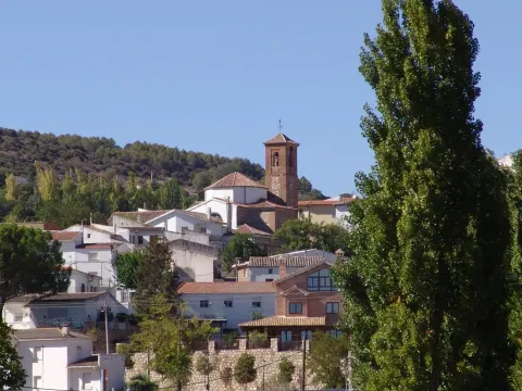
Valdelaguna is a “viewpoint population” on the slope of the stream of La Veguilla, the streets are tiered on the edge of the agricultural moor and serve as balconies overlooking the deep and fertile valley of the village as it stretches towards the great valley of Tajuña. The cycling route departs from the urban area and showcases interesting environmental contrasts between the mountains of Mediterranean scrub on the Path of the Acebrones, the vineyards and olive groves in the moors of Villarejo de Salvanés, and the hills of esparto grass that appear at the entrance of the historic valley of San Pedro, the route of an ancient Roman road and a major trade route for centuries between the towns of the Tagus and the city of Madrid.
The Tower of Tribute of Villarejo de Salvanés highlights the military, historical, and social power that the population has had in the region. The unique fortress is the remnant of the castle that was the seat of the Order of Santiago, each floor contains a thematic exhibition that completes an interesting and pleasant walk through history.
The route ends in the vicinity of the archaeological site of Santa María and the ruins of the Peirones de Santa María, inhabited since the Bronze Age in a landscape of hills of esparto grass, fig trees, olive trees, almond trees, and remains of medieval caves, places with a notable historical value in the origins of the population of Villarejo de Salvanés.
Types of path
- Path: 28.4 km
- Road: 2.28 km
- Street: 1.89 km
- National road: 1.81 km
- Other routes: 472 m

Route 7 Vega del Tajuña - Morata de Tajuña
Morata de TajuñaWarning: shared space with motor vehicles.
The route runs through the Tajuña River Valley, known as the Garden of Madrid, a historic agricultural landscape linked to the traditional crops of Morata and Perales and the development brought by the Arganda railway in the early 20th century. The valley retains a strong rural and peasant character, reflecting the ancient ways of life of the Las Vegas of Madrid.
The cycling itinerary allows you to learn about the traditional irrigation systems, mills, and other elements of the ethnographic heritage, highlighting the proximity of the Museum of Milling at the Huerta Angulo Mill.
The route begins at the bike station of Morata de Tajuña, follows the path of the old railway and the Cordel de la Galiana, with wide views of the Madrid valley and points of historical interest linked to the Civil War, such as the Suicide Hill. The route descends to the vega via the Camino de San Galindo and the Camino de los Molinos, continues along the Colada Cochinera, visits the gypsum cliffs and the monolith of El Fraile, and ends near the Isla Taray, following the course of the Tajuña River.
Types of path:
- Path: 22.5 km
- Cycling lane: 3.65 km
- Road: 3.03 km
- Street: 1.18 km
- National road: 0.65 km
- Other routes: 0.54 km

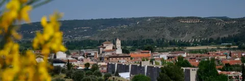
Morata de Tajuña Route - Carabaña
Morata de TajuñaThe Madrid region of Las Vegas has been a territory of railways. The first narrow gauge line in the history of Madrid was built in 1886 between the Niño Jesús station, in the center of the capital, and the town of Arganda. In 1901 the trains reached Morata de Tajuña and in 1921 the railway reached Alocén, in Guadalajara, in a project to connect with the central line of Aragón in Caminreal (Teruel).
The Arganda Train is the well-known Tajuña Greenway, conditioned in the year 1999 between Arganda and Ambite, it was the first Greenway built in the Community of Madrid and served as a claim and expansion of active tourism in the region.
The cycling route starts from Morata de Tajuña and follows a stretch of the Tajuña Greenway through the magnificent scenery of the Risco de las Cuevas, a wall of gullies and gypsum walls with remnants of primitive rock dwellings.
The route runs along the impeccable pavement of the Greenway through the valley of gardens and fruit trees, passing through municipalities such as Perales de Tajuña and Tielmes, up to Carabaña. The streets of this municipality are outside the route, on the other side of the Tajuña river, it is one of the oldest populations in the Community of Madrid and to enter you have to cross the Tajuña bridge, of Roman origin and reconstructed in the 18th century.
Types of path
- Cycling path: 36.20 km
- Road: 6.55 km
- Street: 1.74 km
- Path: 1.46 km
- National road: 0.457 km
- Other paths: 0.316 km

Route 1 Lagoons and Wetlands of Tajuña - Chinchón
ChinchónImportant:
Warning: shared space with motor vehicles.
The Wildlife Reserve Laguna de San Juan is one of the Protected Natural Areas managed by the Community of Madrid. The surrounding area of the reserve constitutes a valuable wetland in the region of Las Vegas, located at the environmental boundary between the fertile agricultural plain and the slopes of gypsum and steppeland cliffs that mark the lower course of the Tajuña River.
The reserve is an important wetland ecosystem for numerous species of waterfowl, which use the lagoon as a nesting habitat or wintering area. The Casasola lagoons (La Lagunilla) and la Espadaña complete these ecosystems, acting as fundamental ecological reserves in the aquatic systems of the agricultural plain of the Tajuña River. These spaces stand out for their notable environmental quality and their exclusivity, as they have not been transformed into farmland.
The cycling route begins in the town of Chinchón and continues through El Valle, the traditional name of the plain of the arroyo de las Carcavillas. In this section, one can observe elements of the local ethnographic heritage, such as ancient chozos, caves, and farmhouses, historically used for the care of gardens and plantations of fig trees, pomegranates, olive trees, and almond trees.
The itinerary traverses the rural roads of Villaconejos, visits the Cueva del Fraile, dated 1734, and accesses the plain of the Tajuña via the Camino de Titulcia. The route crosses the wetlands of the Wildlife Reserve of Laguna de San Juan, which features an ornithological observatory and interpretive panels about the main species of waterfowl. The return to Chinchón is made through the slopes of crystallized gypsum and esparto of the arroyo de las Cárcavas and the Camino de San Galindo.

Route 2 Railways with history - Chinchón
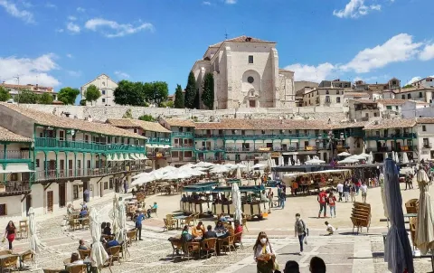
ChinchónChinchón and Colmenar de Oreja are two towns with a significant historical and cultural content in The Madrid Las Vegas, in the last three centuries they have been important commercial centers and were connected to the capital by railway. Colmenar de Oreja was the most industrial town in the province of Madrid until the mid-20th century, the stone from the local quarries was highly valued in construction and had one of the largest productions of wine jars, remnants of several ovens are still scattered throughout the urban area.
The route departs from Chinchón along the old path of the “stone train”, the popular Arrancacepas built in the early 20th century between the main line that traversed the Tajuña valley and Colmenar de Oreja. On the ascent from Morata de Tajuña to Chinchón, the train climbed so slowly that passengers had time to get on and off while in motion to “pull” some bunches of grapes from the vineyards along the way. The first stretch is a delightful rural plain for biking, following the bike lane set up on the old railway track until the entrance of Colmenar de Oreja. The route continues through the historic center and visits the Plaza Mayor, which preserves the atmosphere of the best Castilian public squares and several terraces for refreshments.
The route leaves Colmenar de Oreja via the Paseo del Cristo, passes by the Santuario del Cristo del Humilladero and arrives at Belmonte del Tajo through the pillars of the Parque de las Fuentes, built in the late 19th century from limestone from the Colmenar quarries. At the Fuente de Arriba, water flows from four bronze spouts, featuring a rectangular trough and a pond with a wash area.
Warning: shared space with motor vehicles.
Types of path:
- Path: 31.2 km
- Street: 4.33 km
- National road: 1.40 km
- Other routes: 1.16 km
- Road: < 100 m